Stage 01 - Lands End to Truro
Stage 02 - Truro to Bodmin
Stage 03 - Bodmin to Bude
Stage 04 - Bude to Barnstaple
Stage 05 - Barnstaple to Taunton
Stage 06 - Taunton to Chew Stoke
Stage 07 - Chew Stoke to Gloucester
Stage 08 - Gloucester to Bewdley
Stage 09 - Bewdley to Market Drayton
Stage 10 - Market Drayton to Manchester
Stage 11 - Manchester to Slaidburn
Stage 12 - Slaidburn to Appleby
Stage 13 - Appleby to Gretna
Stage 14 - Gretna to Abington
Stage 15 - Abington to Dumbarton
Stage 16 - Dumbarton to Strathyre
Stage 17 - Strathyre to Pitlochry
Stage 18 - Pitlochry to Aviemore
Stage 19 - Aviemore to Dingwall
Stage 20 - Dingwall to Altnaharra
Stage 21 - Altnaharra to Thurso
Stage 22 - Thurso to John O'Groats
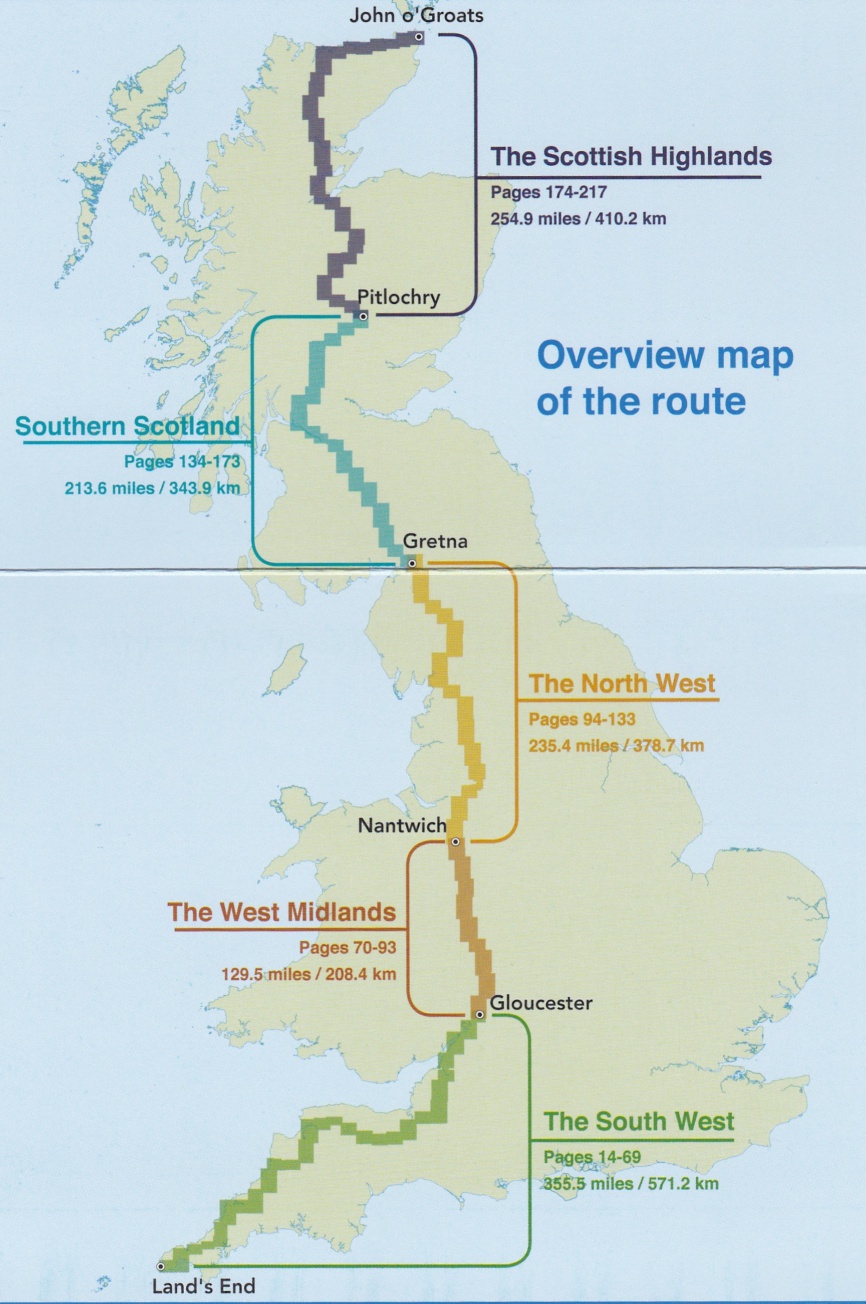
Land's End to John O'Groats
on the National Cycle Network
The map on the left is taken from the official Sustrans guide to cycling from one end of the country to the other using traffic-free paths and quiet roads. The guide is available from their website www.sustrans.org.uk
When I retired and bought a bike I had a thought that I might like to try cycling from Land’s End to John O’Groats. I always intended to do it at a leisurely pace and to keep away from main roads in order to avoid traffic and see some of the more interesting parts of the country. I had started to try to put together a route using Sustrans cycle routes when, in January of 2017, they produced a book in which they had done it all for me - no excuses left.
I spent spring building up my cycling strength and making plans and set off on the 6th of June 2017 with the help of my wife who drove me to the start and then stayed around for the first few stages. She also met up with me in Dingwall for the last stages and to get me and my bike back home. I did most of the cycling on my own except for three days when I was joined by friends.
I was unsure of how I might go and so I stuck with the stages and distances suggested by the Sustrans book for the first four days. I found that I was really enjoying the experience and decided to increase the daily mileage and worked out stages for myself and booked hotels ahead for a few days. The route passes through my home town of Dumbarton so I was able to stay at home and took a day off to cut the grass and wash my shorts (too much information).
I eventually completed the route in 22 days of cycling instead of the 28 suggested by the book. This pace was still allowing me to have regular breaks for lunch or coffee and to take the pictures and video that I have posted here. I was also managing to finish between 5 and 6pm in order to enjoy dinner and write up the events of the day. I did have a few late finishes including one 9pm finish.
I was very lucky with the weather and although there were some showers, there was no persistent rain. The adventure more than lived up to the hopes and expectations that I had for it and I thoroughly enjoyed seeing bits of the country that I didn’t know existed. Route finding was often a problem because the Sustrans trails use old railway lines, canal banks, river banks, housing estates and country lanes. The signage is very good but it is a massive job to keep the signs up to date. Near Dumbarton I came across a Sustrans survey in progress and was able to give them some good feedback having just used about 800 miles of the network.
The highlights for me were the first day which uses quaint country lanes to take you from one coast to the other with picturesque spots on the way - Land's End itself, Mousehill, Penzance and Truro. The first day was special just because it was the first day and the adventure was really under way.
The Camel Trail and The Tarka Trail were easy riding and Bodmin Moor and Exmoor were wild, exposed and hilly. Taunton, Glastonbury and Wells were "quintessentially English" to quote the guide book, including some Morris dancing in the village square at Wells. In contrast you do also have to traverse great swathes of heavily populated England - such as Manchester and that is a very different proposition.
Further north, The Trossachs is difficult to beat for beauty and the Speyside Way, north of Aviemore was probably my favourite stretch of cycling.
The total mileage covered was 1,222 miles which is 22 more than Sustrans indicate but that was because of detours and mistakes by me. More surprising was the height climbed (and descended) which was about 60,000 feet or twice the height of Everest.
ronnie@outandaboutinscotland.co.uk 6th - 28th June 2017